Monday 18 September 2017

The Pantanals, Brazil.


The Pantanal in Brazil

The Pantanal is a vast area of Brazil. It is regularly flooded in the wet season, and as such supports an eco system that is unique in the world.
I understood from my research that the area was heavily impacted by cattle grazing, but I was surprised by how much. One gets the feeling that it is a part of the natural world that would have once been absolutely spectacular, but it has been reduced in size so as to be, for us, a bit of a disappointment.
Some Overlanders we met went on a Jaguar sighting boat cruise and proudly emailed us some shots of their sightings. However it is widely rumoured that ground crews are known to drive the animals to the vicinity of the river for 'viewing' plus it was stinking hot so we didn't go.
We did find a fantastic variety of birds, and found the experience of visiting the area in itself to be another amazing experience in this part of South America.


It is a long drive east though Bolivia to the Pantanal of Brazil. But it was the right time of year to visit, so, a round trip of 3000 klm was necessary for us.


Caimans relaxing on the river banks. A common sight.


Not as big as the Australian salt water variety. No doubt they could still give a nasty nip though.


Looks like a Heron, maybe.


Looks like a weaver nest, maybe.


Another Heron, perhaps.


Capybara, for sure.


Two Australians, Robert and Clary from Queensland in this monster truck.


Ibis? I think so. Maybe.


Red crested Cardinal. Yes!


Woodpecker.


Cuckoo


Locals river accommodation.


Camping at Jaguar Camp, Porta Jofre, Pantanal, Brazil


An old Merc. Heaps of them in South America. Glad I'm not paying the fuel bill.


Jungle walk. Pretty warm so best not to go too far.


Hyacinth Macaw. YES!!!!


Gael back from the hairdressers. Not happy with the cut!


Amazon Kingfisher. Definitely.


Tourists on Jaguar spotting trip.


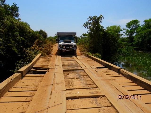
The bridges suffer a bit during the wet season.


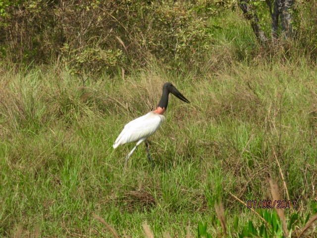
Jabiru. A nice example, I think.
Friday 15 September 2017

Bolivia

Bolivia

After driving along the southern shore of Lake Titicaca in Peru we cross into Bolivia. 

La Paz the Bolivian capital offered little that we were looking for so we moved on further east towards Santa Cruz. The road gradually looses altitude as it drops down into the Amazon basin and the border crossing into Brazil.
Lots and lots of police check points in this area along the Bolivian/Brazil border as it is popular with smugglers. Have no idea what is smuggled but your movements are monitored closely by the military.

After our brief crossing into Brazil and the Pantanal wetlands we backtrack into Bolivia again and head towards, Sucre, Potosi and eventually the salt lakes of Uyuni.
The scenery in Bolivia takes in lakes, mountains, wetlands and the high Altiplano. Amazing variety!

One of the most frustrating parts of traveling in Bolivia is getting fuel. Foreign registered vehicles have to pay more for theirs and not all service stations want to sell it to you. Pump sales to foreigners are closely monitored with surveillance cameras. You often have to park away from the service station, walk to the pump with a jerry can, and lug it back to the vehicle to fill your tank. After I had humped several 100 litres around the block on various occasions, I was less than satisfied with the system they have in place.

Like Peru, Bolivia could do with a good vacuuming!


Only place to camp before the Bolivian border was this small camp site behind Hotel Casablanca in Peru overlooking Lake Titicaca. Paul, an Aussie and his family, camped beside us in the slide on camper they purchased in the States. They were driving it to Southern Argentina where they were going to sell it to someone going north. We caught up with them a few times on our way south.

Camped beside Lake Titicaca on the Bolivian side near the town of Copacabana just visible in the distance. Copacabana is the largest town on the shore of Lake Titicaca in Bolivia.


Eucalyptus poles for sale with La Paz unique architecture in the background.  La Paz  took some getting into as there were some unhappy locals who decided to cover the road from Titicaca in rocks of assorted sizes. We headed off road (along with everyone else) across farm paddocks and back roads to enter La Paz through the back door.
La Paz can be variously described as a chaotic, dug up, and congested.


Busy market but didn't stop . We wanted to get thru La Paz as it was chaotic.


She's just bought a nice new llama.

Well what a difference Sucre was.  In stark contrast to dusty La Paz.


Lovely colonial style buildings. You can see why Sucre is called the white city.

Tiny back yard Sucre camp ground of Alberto and Felicidad. We squeezed in with seven overlander campers from all parts of the world.


We came across this beautiful bridge on the way out of Sucre. Going nowhere. Quite bizarre.


We drove the Che Guevara Route across a rugged mountain track. Che came to his final end at the hands of the pursuing Bolivian police, ably assisted by the CIA, in the village La Higuera. After capture he was executed. Trials are expensive!


Yes, that is a sheep standing on top of a bus. He has a wild ride ahead of him over the rough mountain roads of Bolivia.


Herds of these llamas with their colorful ID tags roam the vast Bolivian landscape.  Pretty flash eh.

Warning of more up ahead.


That's us. The little dot in the middle. We camped all alone on the edge of an amazing canyon on the road to Potosi. Remote and quiet, the only movement were condors soaring above.


A hangman effigy dangling from a signpost is a reminder to the bad guys of the rough justice handed out by the locals. Vigilante justice is common against criminals in Bolivia, apparently 70% of crimes are dealt with by locals who don't have much confidence in the police.


Not many places to camp on the way to the Brazilian border and the Pantanal wetlands. This was a gravel pit not far from the road.


That's Rob over the road at a military check point near the Brazilian border. We were stopped at eight on the way, they wanted to see our temporary import permit and passport mainly. Manned by young guys with machine guns trying to act tough and important. Rob always managed to return with the appropriate stamp on our documents.


What an amazing ornately carved huge church. Surprising to find this in San Miguel eastern Bolivia.


At last Toucans on a bush track just near a small village called Santa Ana de Chiquitos where we camped just on dusk.  The women in the village gave us the OK to camp near the village school.


Bypassing Potosi on the way to the salt lake at Uyuni. Potosi is a mining town that the Spanish used to fill the vaults back home. At an elevation of over 4000 metres it can get cool. 


The rubbish on the roadside in Potosi was horrific. A dusty, polluted, dump of a place where the local Bolivians scratch out a living. It would have to be one of the dirtiest places we have passed through in South America. Reminiscent of parts of Morocco half a world away. So depressing, but so, so, common. Our planet deserves better!
The contrast between Sucra and Potosi is stark! 


The salt lake just outside Uyuni (another shitty Bolivian town). A tourist hub that has tourism focused on the salt lakes as its main money spinner. The town itself offers little, other than serving as a base for what must be thousands of 4x4's, that ferry thousands of sheeple to the salt flats, and surrounding Laguna's. 


The Laguna Route.  A very rough, high altitude, but stunningly beautiful drive past volcanoes and colorful salt lagoons dotted with flamingos. A must do drive from Uyuni in Bolivia to San Pedro De Atacama in Chile. 


We couldn't believe our eyes when we came across a cyclist on the bleak, freezing, windy and dusty drive at above 4000 meters on the Laguna route.


And here he is all the way from Switzerland. He was grateful for the vegetables which we gave him. He was the toughest cyclist we had met on our trip. A super human effort.


Gael trying to take that perfect shot, but they show little interest.


The lakes were full of them. Just great.

Red Laguna, the white dots are flamingos.


We came across these strange ice formations all along the Laguna Route. It looked like it was growing out of the ground.  We wild camped along the route for several nights. At 4,400 meters it was perishingly cold.
Our water bottles, left on the bench top overnight, were frozen solid in the morning. 


Pretty little Vicunas.  How they survive in such a harsh salty environment on the Bolivian Altiplano is incredible.