Monday, 21 August 2017

Stunning scenic Peru but with serious environmental issues.

Pisac Sacred Valley.


Peru 

The crossing from Ecuador into Peru was fairly uneventful although a bit drawn out. They don't get a lot of Australian registered vehicles over this way, so the paperwork takes a while.

We were in Peru back in 2014. On that occasion we did the tourist hot spots with the other sheeple of a like mind, Machu Picchu, Lake Titicaca, Puno to Cusco train ride, Colca Canyon, etc. All major tourist draw cards for Peru and on the established tourist loop.

This trip has seen us cover a great deal more of the ‘real Peru’. Stunning scenery tempered by the necessity to drive some of the worlds most dangerous roads. The northern half of the country inland route N3 traverses some truly mountainous country. With mountains ranges like the Cordillera Blanca come truly terrifying though spectacular roads. There are in fact fifteen plus 6000mtr peaks to be found in this one mountain range. Spectacular!!

Peru is much poorer than its northern neighbors Colombia and Ecuador. This is evidenced by the poor standard of housing (mud brick) and the noticeable poverty. 
Rubbish is a shocking problem in Peru. Low standards of environmental education and education generally, poor infrastructure, and apathy, mean that Peru has some serious environmental issues.

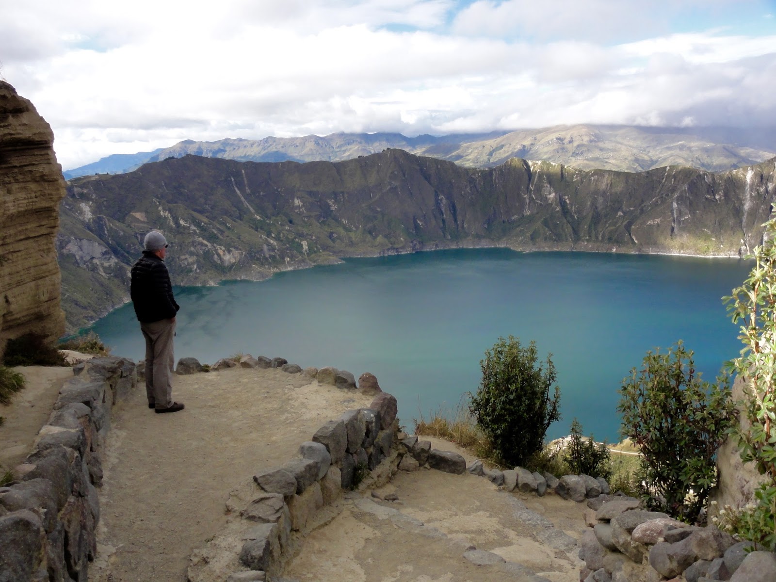
Rubbish of the towns aside, Peru has some absolutely stunning natural scenery. And of course there are the Inca ruins to marvel at.


If you zoom in you can see Rob standing at the bottom of one of Yumbilla Falls near Chachapoyas, Northern Peru in the Amazons region. It has several sections and is 3rd highest waterfall in Sth America and the 5th highest in the world.

                                                                     
There he is.


This is Santiago a real character and
photographer from El Salvador we met at our camp at the trail head of Yambilla Falls


Just a few kilometres away were the 4th highest falls in Sth America, Gocta Falls. Impressive eh!

Hiking to  Pre Inca cliff burial tombs.

And this is what we saw.

This road was pretty scary. One lane, with oncoming traffic, cliffs one side, blind corners and a 800 to 1000 mtr plus drop. A previously heavy rainy season had under cut the bitumen in many places on the drop off side.


We camped here on a dead end road to a Pre-Inca fortress.


Early mornings on the road, saw ladies after milking their cows in the paddock, walking the milk cans to a truck pick up point.

Animal market day roads were choked with people walking their animals
down to the action. Not impressed when the bull with the big arse nearly wiped out the trucks side mirror.

The first nice Peruvian camp site at Hacienda San Antonio in Cajamarca. A chance to catch up with some washing.

Cajamarca a typical  Peruvian city.

Pre Inca aquaduct cut 3000 years ago with stone tools pretty amazing and it still works.


It looks like after we drive down to the river in the valley, we'll be going up the other side.


 Yep! That's what my Maps.Me navigation app. is telling me.


Sacrifice towers at pre inca plateau fortress Marcahuamachuco.


The plateau fortress was over 2kms in length and had a 360 degrees views of the surrounding area.


Sad to see plastic rubbish dumped outside every town. 


Most farmers still use oxen and with a basic wooden plough.

                           
This section of Canon del Plato was hairy with crumbly rock overhangs.


We counted about 40 tunnels like this in the canon.  A stunning drive with massive mountains above and a river in the valley.
We met a couple who managed to get their 12 tonne truck stuck in one of these.
Small can be good when it comes to clearance in tunnels, overgrown tracks, passing under overhanging tree branches, driving narrow roads with crumbling edges, crossing load limited bridges (of which there are many in rural Sth America), etc, etc.


This is tall hat country, they look weird.


Cusco and the incredible Incan fortress Sacsaywaman.


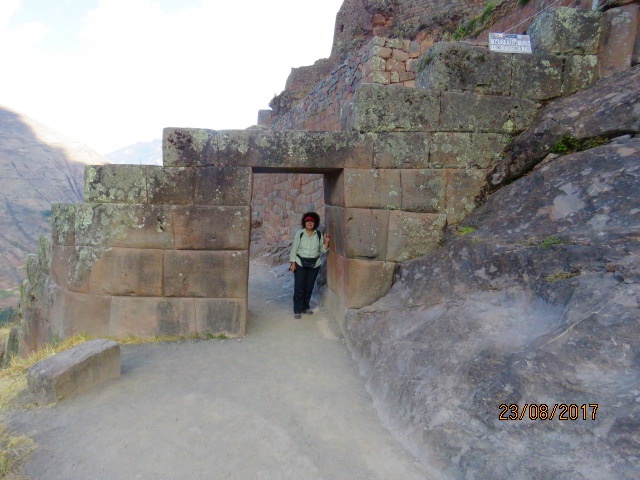
The Sacred Valley has so much to see. This is the ruins of Pisac. An amazing Inca site high on a mountain.


The Cordillea de Blanca circuit drive, fabulous scenery whilst passing through small rural villages.


More stunning scenery. 


Where you have stunning scenery, you more often than not have some challenging roads.


Moray Inca site has some amazing agricultural terracing.


Saltia Inca salt works of Peru. Still in use today.

Met Jonno from Perth riding from Ushuaia (the southern most point), to Colombia (the northern most point) of the south American Continent. Gael gave him a jar of Vegemite which he had been craving. The push bike riders we met in South America are a breed apart! Real adventurers, not pussies like us.


Carved out of solid rock. A ceremonial Inca platform at our lunch break stop beside Lake Titicaca.


Taking a ferry across Lake Titicaca from Peru to Bolivia.
Life is good!

Monday, 31 July 2017

Further travels in Ecuador.


Ecuador to Peru

We find ourselves back in Ecuador after spending quite a bit of time early in May at Galapagos and the area north of the capital Quito.

This time we moved fairly quickly through the north of the country to focus on the south and the Ecuadorian Amazon. Ecuador, like Colombia, is heavily populated (compared to Australia that is) although it is covered to a greater extent in small agricultural holdings as the land is more fertile. Here the locals scratch out a living from the soil with the aid of oxen or the strength of their own backs. 

The climate at this time of year (June/July) is perfect, as it is for most of the year if you ask the expat community. Although on the equator most of inland Ecuador is at altitude so the weather is very pleasant. 
With a great climate, cheap cost of living, and the rent of a nice three bedroom country villa coming in at US$300/month, places like Vilcabamba in the south are popular. Americans on the pension could live very comfortably here, and they do. 

The regional tourist towns in Ecuador are less well presented than the equivalent in Colombia, but they are surrounded by wonderful mountain scenery. 
Some towns, like Banos however, in a stunning location in the Amazonian highlands, have been turned into what could be considered to be nature theme parks.
Situated in a naturally stunning deep river valley it has been turned into a bloody eyesore. There are zip lines everywhere, thermal baths, and grungy night spots litter the main street. Open sided buses, blaring loud tasteless local music (in my opinion), cart what must be brain dead Ecuadorians and others, from one man made eyesore to another.

Getting around is still painfully slow, and dangerous by Australian standards, so fewer Ecuadorians appear to own cars and the local buses are cheap, although this could also be due to economic factors.

With extended Overland travel in a vehicle comes roadside/camping ground/or carpark maintenance. I had to replace the clutch master cylinder on the dream machine whilst camped in a car park  by South Americas third highest waterfall the other day. I was bitching to myself about having to replace it again after what seemed only a couple of years. When I checked my service logbook it was actually in 2007 whilst returning from a trip to West Australia. When you hang on to a vehicle for twenty four years one loses track of time. It pays to keep a record!


Never let an opportunity to turn a natural feature like a cave into a religious icon pass you by in Ecuador. All those roses were fresh.


The cave entrance as seen from up the river.


The Otavalo market in the town of the same name in Ecuador. some great sights to be seen and some great local art.


 One of the locals killing some time after shopping for dinner, which is under her arm, and still           very active.


On the road to Cotopaxi volcano central Ecuador south of Quito.


How you can out run a volcanic eruption is beyond me.


Local artist signing an example of her work for Gael in the town of Tigua famous for it's primitive art style.


Stunning Ecuadorian scenery in the area of Tigua.


Looking into the crater lake at Laguna Quilotoa. It was freezing up here at night where we camped in the town square.


Our camp in the Ecuadorian Amazon .


At last a Macaw.

Gael armed with binoc's and camera she's not going to miss a thing.


A caiman lurking near our camp.

Thursday, 20 July 2017

Beautiful, green Colombia.


The need for a Brazilian Visa

Unfortunately we have to get a Brazilian visa to visit the Pantanal area of Brazil (just across the Bolivian border) when we get down that way in a month or two. Brazil is the only country in South America that requires a visa for entry, so for us it meant a visit to their embassy in Bogota.

We have been to Bogota on two previous occasions, only for short periods of time, but long enough to see the wonderful Gold Museum, and be convinced that I never wanted to drive there. 
Well, like it or not, this is exactly what we had to do. Gael did an admirable job of navigation but my interpretation of her fast flowing instructions did, at one point, give us the unique experience of driving on one section of the centre road reserve, bus only, transit lane.
Once on these bus transit lanes they are not easy to get off, however, stricken with panic, we managed to impress the local Bogotonians with our kerb climbing ability as we merged seamlessly with the bumper to bumper traffic in the parallel lane.

At the Brazilan Embassy the next day we received instructions in Spanish, from a not too interested admin officer, that we needed to fill out an online visa application, in Portuguese, we think, at a local internet cafe. After the first mind numbing hour I was in a hairs breadth of stepping outside the internet cafe and throwing myself under a bus when two twenty something girls on the computer next to ours offered their assistance. With the girls help, and that of another local young gentleman visiting the embassy, we got our paperwork submitted before closing time.

Initial advice was that it would take twelve days to expedite our visa application, but after discussions with the the vice consul, and explaining we were traveling differently to most applicants, we received an email two days later to say that the visas would be ready in only five days. Great service after Gael found a way to bypass the disinterested front of house staff.

We have zig zagged our way south through this stunningly picturesque country visiting as many points of interest as we can, including historic Colonial towns. 
Moving around Colombia is torture for the old truck though. Up and down 3,500 meters at a time over mountain ranges that run the length of the country. Crawling along behind lines of semi trailers moving at a snails pace over mountain passes and being held up by roadworks for several hours every day. Everything in this country moves by road, as the only rail transport company was liquidated in 1990.

We read a couple of days ago that in 2016 deforestation in Colombia increased by 44%. This probably goes some way to explaining why we have not seen any, not one example, of ground dwelling wild life. Every piece of this country, that can be, is cultivated. With around 45 Million hungry mouths to feed you need to grow a lot veggies.

However even with its few shortcomings Colombia comes highly recommended. 

On to Ecuador.........


I find several sharp blows to the forehead does wonders after a day at the wheel in South America.
Our 'camping' spot for the night in a 24 hour carpark. Secure and with shopping plaza next door.


El Penon at Guatape is a popular tourist town with an extensive lake system (hydro). In South America if you have a beautiful natural feature the obvious thing to do is to improve on it! In this case a stairway.


 Cheap local transport. I had to convince Gael not to ride on the roof.


Each dwelling has a themed relief art.


Again outside a pub!


Spent a few hours with Stuart who spotted our truck in Manizales. He is an Aussie who has sold up everything in WA to move to Colombia with dog Penny. At 55 he sees many happy years ahead of himself with his current (or a future) 30 year old Colombian girl friend.


Driving East/West across Colombia means crossing several mountain ranges. This is done at a snail like pace with heavy transport making the trip interesting. Brake maintenance or the lack of it sees many large rigs go arse up.


                                                 Beautiful, a member of the ginger family.


and again


Getting a bit of exercise in Salento. The area is in the coffee triangle and is a magnet for backpackers.


The jeeps were used to cart coffee beans at one stage and some may still do.They call them Willy's. But in the main they are used as taxis and provide a buzz for the tourists.


Following a jeep load of thrill seekers. I wonder how their travel insurance would view this risky transport if they fell off. 


Tourism is big in Salerno.


Wax palms grow to 60 metres high and grow for one hundred and twenty years. They are the tallest in the world I understand. Lucky for the local economy they weren't bowled over when the land was cleared  for grazing. 


Truly stunning country.


One of our campsites for a couple of nights near Salento. A twenty minute walk to the centre of town.


Local transport at the town of Los Lajas where the amazing church below is found.
Whilst walking through the gorge one night several hundred years ago apparently Rebecca's daughter Maria had a vision. This was enough to send the local priest into a frenzy of crowd funding.


                                                      Beautiful. Both of them!